Wow. I fail at blogging. Anyway, since I last posted just under a year ago, I have moved to Utah. I live in a city in Northern Utah, practically in Idaho. I've done a ton of roadtripping around here - there's so much to see and so little time! I'm moving in October when my position ends, but I don't have a destination in mind.
I think I'll do some "update" blog posts, but a quick overview of my travels since last August:
-late September was the crazy 23 hour road trip to UT by myself as I moved across the west
-early November I went to a VISTA orientation in Salem Oregon
- Thanksgiving I went back to Salem to hang with family
- in late December, early January I was home with family and it was gooood
- in late January my roommate and I drove to Jackson, WY to see the Alonzo King's LINES ballet
- in February, I drove back to Jackson to go to a Crooked Still concert, which was pretty amazing
- in May I went to Idaho to see my sister (who was visiting there from Portland)
- I also went to Bryce, Capitol Reef, Zion, and Escalante National Parks/Monument - amazing amazing amazing.
- in June I went home again (home again, jiggity jig) and had a blast
- for the 4th I went to Seattle with my roommate
- In late july, my roommate and I went to Grand Teton National Park and Yellowstone - impressive
And in a week, we leave for Portland, and then Eugene, and then a massive roadtrip that will include Crater Lake, Glacier, and Canada! Woohoo!
Saturday, August 6, 2011
Friday, August 20, 2010
Sittin in a railway station. . .
Got a ticket for my destination.
I'm pretty much all packed, and am now staying with Becky in her apartment to facilitate taxi pick-ups and apartment key drop offs. We went out for dinner at a mirador in Cedros that overlooks the city. It was pretty incredible. No time for photo uploads - maybe another time!
Headed to Colorado for a few days before road-tripping back to Minnesota with mom and dad. Should be pretty sweet!
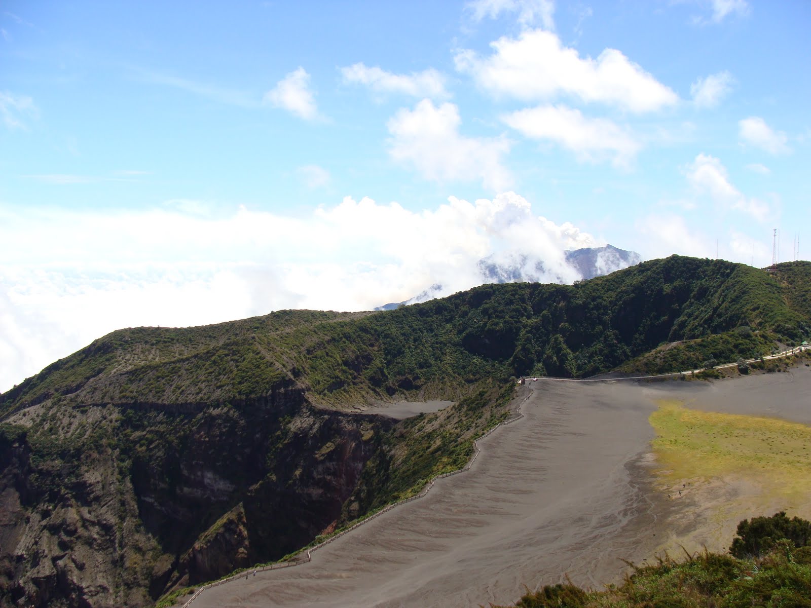
Volcan Irazu
My final trip in Costa Rica was with Becky and Ruth to Volcan Irazu. Irazu is the highest active volcano in Costa Rica, and by the time we reached the top, we were above the cloud layer, which was pretty cool.
The summit is 3,432m, which is about 11,260 feet, high. On clear days, you can see the Pacific and the Atlantic. I thought I maybe saw the Pacific, but I don't really know - and its really rare to have a day that is clear enough.
Anyway, Ruth, Becky and I drove up Irazu, which is outside Cartago. The road winds up the mountain, and you can drive pretty much all the way up the summit.
Because volcanic soil is good for agriculture, the sides of Irazu are covered in farms, growing all sorts of crops. As we drove up the road, we passed pick-ups full of farm workers headed to the fields for the day, or changing fields.

From the summit, you can see the main crater, as well as Cartago and other volcanoes and mountain peaks. We could see Volcan Turrialba, which has been smoking for about six months now.
The main crater has a lake in it, but we were unable to see it. The crater is pretty deep, and looks (to my admittedly very poor volcanological eye) like it was created after a larger crater.
From the summit, there is a steep, maybe 60m drop off to a more or less flat plain, which then drops off again to the main crater. That plain is mostly covered in grey, dusty, ashy soil, but there is a part in the center where they are trying to regenerate growth. Its covered is low ground cover - think creeping charlie type - and taller grasses.
Irazu was pretty stunning in terms of vistas, but it doesn't look "volcano-y". (A very technical term meaning its not smoking or doing anything interesting, really). And I had a great time hanging out with Ruth and Becky. Plus, the drive up was beautiful - whats not to like about views off the side of a mountain on a clear sunny day?
 |
| Ruth and me at the summit, toward Cartago |
 |
| Main crater in the front left, with Turrialba smoking in the background. |
 |
| Farms farms farms! |

From the summit, you can see the main crater, as well as Cartago and other volcanoes and mountain peaks. We could see Volcan Turrialba, which has been smoking for about six months now.
 |
| Volcan Turrialba |
 |
| From visitor's center, looking at the summit. That's a TV tower. |
 |
| Grasses and flowers on the plain |
 |
| View off the side of the mountain, on the road up. Cartago would be in the valley |
Tuesday, August 10, 2010
Volcanes, Churches, and Ox-Carts: Oh my!
We had a new work group here last week from Texas. They were really fun, and taught me an awesome game you play with dominoes called chickenfoot. It was especially awesome because my first time playing I cleaned their clocks. They elected to do two day trips. One was the trip I'd been on already, to Sarapiqui, but the other was to Volcan Poas, Grecia (a small town), and Sarchi (another small town). Ken, who is the tour guide the UBL works with, and his wife Delia joined the group, which was lovely for two reasons: Ken is a birder, and could identify birds, and Dely is Costa Rican, so there was someone I could speak Spanish with.
We drove up to Poas through fields of coffee and ornamental plants - which are apparently Costa Rica's fourth largest agricultural export. (You learn a lot when you travel with a tour guide). The road was lined with the houses of the farm workers. Because of the relative stability of the climate, Costa Rica doesn't have a lot of migrant farm workers. Rather, they work in the same place year round, since there is always something to do.
Poas is one of the most visited national parks in Costa Rica, partly because it is an easy drive from San Jose - and there is a public bus that runs from downtown to the park and back. It is one of the five tallest volcanoes in Costa Rica. It doesn't really have a peak, though. It has three craters, two of which are visible to the public. Both are lakes, though one is a sulfuric lake that's about 50 C, and the other is a fresh water lake that's very cold. Both are really beautiful, but in very different ways.
The crater principal has several fumaroles that smoke constantly, so that the lake is never clear. That smoke can get caught in the crater, and then blown up to the viewing point - which is really gross, because it smells like sulfur. While we were up there, that happened twice, and the sulfur smell is so strong it made my throat hurt. The crater itself is very wide, and the lake is in a secondary crater inside it. The whole crater is just rock and dirt; there are practically no plants. There is a road that runs along the crater, which is for vulcanologists and other researchers.
The second crater, about a 30 minute hike from the crater principal, is completely different. It looks more like a glacial lake (except for the fact that the foliage is all rainforest plants) than a volcanic lake. (I don't know what I thought a volcanic lake looked like. This lake wasn't it.) The water is very blue, and looks super inviting. According to legends, the lake was used as a sacrificial altar, with people/things being sacrificed to appease the gods so the volcano didn't erupt. I don't know if this is true; I didn't see anything about it in the museum.
We hiked to the crater principal while it was covered in sulfur smog, and then got to watch it all blow off, which was really amazing, because the whole crater cleared up and became visible. Then the men in the group, Ken, Dely, and I hiked to the lake, and then back down the mountain to the park entrance. We saw a ton of birds, including the volcano hummingbird, which is endemic to Poas.
From Poas, we went to Grecia. We ate at a trapichero, or a sugar cane mill. We got to try raw sugar cane (yum!) and the final taffy (also yum!). We had cane juice at lunch (kinda yum. also tasted green.).
Grecia is famous for its church. The church is all metal, and was shipped from Belgium to Costa Rica in the mid 1800s, and carried over the mountains by ox-cart from the port (no one knew if it was Puntarenas or Limon, but either way, there are mountains). The town was hoping that a metal church would be more stable during earthquakes - as it is still standing, I would assume that it is. Costa Rica as a whole has very few historic buildings because earthquakes demolished the vast majority of the colonial buildings.
From Grecia we went to Sarchi, which is mostly famous for the ox-carts that are produced and painted there. I didn't really take any pictures, but the ox-carts are very colorful and pretty. Mostly we shopped in Sarchi, but its mostly grown-up stuff (aka not cheap. at all.)
 |
| Stunted Forest: this is what we hiked through |
 |
| Volcan Poas: the main crater |
 |
| You can see the sulfuric lake. The smoke is rising from the fumaroles. |
 |
| See that pale line along the ridge? That's the road. |
 |
| The Lake |
 |
| Volcano Hummingbird |
 |
| The group in front of the trapiche and water wheel. |
 |
| The metal church. Looks pretty normal, doesn't it? |
 |
| Dad, I took this photo for you. |
Sunday, August 8, 2010
Guanacaste: Playa Hermosa!
 |
| Volcan Arenal from the road |
Becky and I took a road trip in her new(old) car. We drove over the mountains and down into Guanacaste. Guanacaste is the "dry" region of Costa Rica. It is hot and dry during the dry season (now) and cooler and rainy during the wet season. The region is named for the Guanacaste tree, which is Costa Rica's national tree. Guanacaste is bordered on the east by the volcanic mountain range, to the north by Nicaragua, to the west by the Pacific and to the south by the Rio Tempisque and the Golfo de Nicoya. It reminded me a bit of Iowa - the landscape along the road is dominated by rolling plains, though there was some forest as well. The region is mainly cattle ranching, but they also grow sugar cane and cotton.
 |
| sugar cane field? |
Becky and I took the Interamericana (also known as the Central American leg of the Pan-American Highway). We saw a huge variety of ecosystems, which was cool. We drove through cloud forest, rain forest, and flood plain. We also saw a lot more of San Jose than we had intended - it took over an hour for us to figure out how to get onto the Interamericana.
 |
| Interamericana in Guanacaste |
 |
| Rooster at the restaurant |
 |
| The beach from the tidal pools |
 |
| Sea slug |
 |
| Sea urchins |
We spent the night in Playa Hermosa, and left to go back to San Jose a little before noon. We had rain for a large portion of our drive, but it was, luckily, clear while we were driving in the mountains. We stopped in San Ramon, a small town outside of San Jose to look for food, but we didn't find any. What we did find was a green - that hospital green - evangelical church. Unfortunately, my camera battery died, and so I don't have any photos of it, but it was quite the sight to see.
One of the cool things we saw on our way back to San Jose was a group of pilgrims walking to Cartago. August 2nd is the Feast Day of Nuestra Virgin de los Angeles, and a large number of catholics make a pilgrimage to Cartago in honor of La Negrita. The pilgrims we saw were walking from Tilaran to Cartago, which is about 150 km, up and over a mountain range. It was pretty impressive.
 |
| Blurry pilgrim! |
Thursday, August 5, 2010
La Selva
It seems that I can't really get outside of the Parque Nacional Braulio Carillo these days. I spent a day and a half at the Organization for Tropical Studies Biological Reserve La Selva, which is a fancy way of saying place for biologists and students to research. I know that Hart and Ben have both spent time here - I felt like a scientist!
Anyway, I went on this trip with about 20 students from the UBL, and I was the second youngest in the group. We were accompanied by four professors, two of whom were actually the trip leaders. Roy and Janet are a married couple who teach at the UBL, and Roy is somehow connected to the Costa Rica Ornithological Society - I think someone told me he was the president. We left San Jose at about 6:30am on a bus, and much of the group spent the trip singing. We arrived at La Selva by about 8:30, and took a 3 hour hike through the park, split into several groups. We saw massive spiders - the size of my palm, tons of birds, peccaries, bullet ants, leaf cutter ants, and some monkeys. (Bullet ants are one inch long. They terrify me. Their bite supposedly hurts for about 24 hours. These ants are things of nightmares.) After the hike we ate lunch, and then went to a talk about La Selva and the environment, the fieldwork that goes on there, and Costa Rica in general. It was very interesting. But even better was the fact that the room we were in was air conditioned. La Selva was incredibly hot and humid. Unbelievably so. I sweated sitting still in shade - my jeans were pretty much wet by the time the hikes were over. In the evening, we went on a night hike, which was really cool. Unfortunately, my group didn't really buy into the whole "if we're quiet we'll see more animals" bit, which I found frustrating. We did see a ton of frogs, spiders, walking sticks, praying manti, snakes, and an owl, plus a sloth!
The next day, I went with Roy as he hiked and bird watched, which was really interesting. I got to see a lot of birds, and have them identified. It started to rain at about 8:30am, but settled to a misty-drizzle, so Roy and I continued hiking. Once we got out on the trails, though, it really began to pour - we both became completely soaked. I was really glad I'd borrowed rain boots from the guides, because we were walking through puddles in places that came up to my ankles, and water was running down the trails. We got a bit turned around, and ended up being late to meet with the bus, but it was lucky I was with Roy, since Janet was annoyed with him - the "responsible" one - and not me. By the time we reached the bus, it was too late to change, so we rode the hour and a half back to San Jose completely soaked. Despite that, it was a super fun, if exhausting trip. I've discovered that I enjoy birdwatching when interspersed with hiking in the rainforest (or riding on a boat in a river, or climbing a mounting, or just about anything as long as I'm not stationary). Anyway, I think I've spent enough time in that area of the country, and I should probably branch out some.
 |
| Iguanas! They're everywhere! |
 |
| This is the trail we used for the night hike. It translates: Singing Frog Trail |
 |
| One of the main trails; Roy and I started our hike here. |
Saturday, July 31, 2010
Volcan Barva
 |
| Volcan Barva from the street I live on |
 |
| Road Sign - I passed at least 3 |
 |
| view of the central valley -aka San Jose - from the road |
 |
| View down the road once the fog rolled in |
 |
| Trees along the trail |
 |
| Poor Man's Umbrella - the purple thing is my winter hat |
On that trail, I passed (among other things) a thistle that was taller than I was, and grasses that came up to my shoulders. When I reached the summit, there was a lookout platform over the crater lake, which is about 70m in diameter.
 |
| Laguna Barva |
 |
| Trail Markers |
 |
| Pretty Flowers from the trail |
Subscribe to:
Posts (Atom)