Got a ticket for my destination.
I'm pretty much all packed, and am now staying with Becky in her apartment to facilitate taxi pick-ups and apartment key drop offs. We went out for dinner at a mirador in Cedros that overlooks the city. It was pretty incredible. No time for photo uploads - maybe another time!
Headed to Colorado for a few days before road-tripping back to Minnesota with mom and dad. Should be pretty sweet!
Friday, August 20, 2010
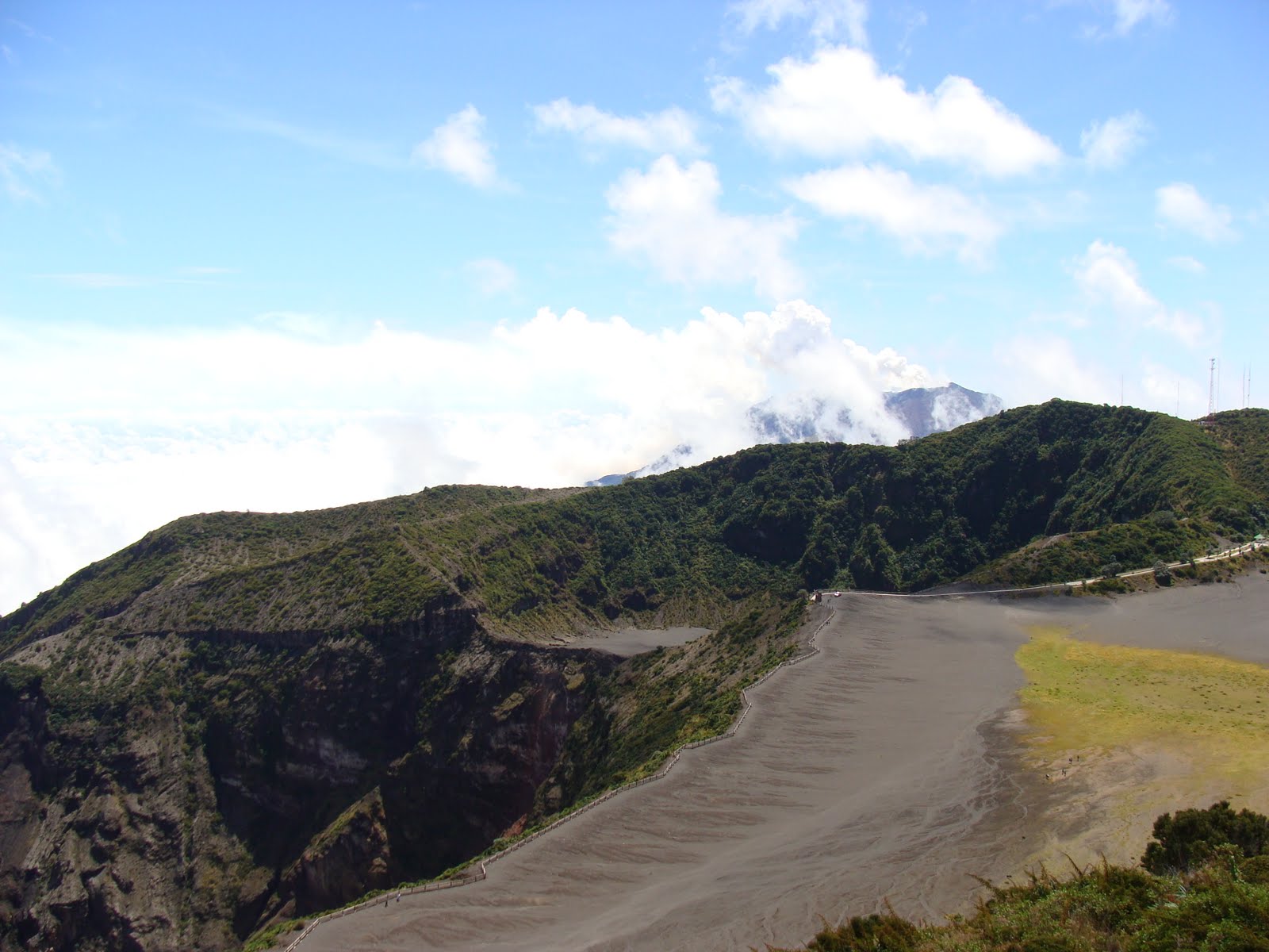
Volcan Irazu
My final trip in Costa Rica was with Becky and Ruth to Volcan Irazu. Irazu is the highest active volcano in Costa Rica, and by the time we reached the top, we were above the cloud layer, which was pretty cool.
The summit is 3,432m, which is about 11,260 feet, high. On clear days, you can see the Pacific and the Atlantic. I thought I maybe saw the Pacific, but I don't really know - and its really rare to have a day that is clear enough.
Anyway, Ruth, Becky and I drove up Irazu, which is outside Cartago. The road winds up the mountain, and you can drive pretty much all the way up the summit.
Because volcanic soil is good for agriculture, the sides of Irazu are covered in farms, growing all sorts of crops. As we drove up the road, we passed pick-ups full of farm workers headed to the fields for the day, or changing fields.

From the summit, you can see the main crater, as well as Cartago and other volcanoes and mountain peaks. We could see Volcan Turrialba, which has been smoking for about six months now.
The main crater has a lake in it, but we were unable to see it. The crater is pretty deep, and looks (to my admittedly very poor volcanological eye) like it was created after a larger crater.
From the summit, there is a steep, maybe 60m drop off to a more or less flat plain, which then drops off again to the main crater. That plain is mostly covered in grey, dusty, ashy soil, but there is a part in the center where they are trying to regenerate growth. Its covered is low ground cover - think creeping charlie type - and taller grasses.
Irazu was pretty stunning in terms of vistas, but it doesn't look "volcano-y". (A very technical term meaning its not smoking or doing anything interesting, really). And I had a great time hanging out with Ruth and Becky. Plus, the drive up was beautiful - whats not to like about views off the side of a mountain on a clear sunny day?
 |
| Ruth and me at the summit, toward Cartago |
 |
| Main crater in the front left, with Turrialba smoking in the background. |
 |
| Farms farms farms! |

From the summit, you can see the main crater, as well as Cartago and other volcanoes and mountain peaks. We could see Volcan Turrialba, which has been smoking for about six months now.
 |
| Volcan Turrialba |
 |
| From visitor's center, looking at the summit. That's a TV tower. |
 |
| Grasses and flowers on the plain |
 |
| View off the side of the mountain, on the road up. Cartago would be in the valley |
Tuesday, August 10, 2010
Volcanes, Churches, and Ox-Carts: Oh my!
We had a new work group here last week from Texas. They were really fun, and taught me an awesome game you play with dominoes called chickenfoot. It was especially awesome because my first time playing I cleaned their clocks. They elected to do two day trips. One was the trip I'd been on already, to Sarapiqui, but the other was to Volcan Poas, Grecia (a small town), and Sarchi (another small town). Ken, who is the tour guide the UBL works with, and his wife Delia joined the group, which was lovely for two reasons: Ken is a birder, and could identify birds, and Dely is Costa Rican, so there was someone I could speak Spanish with.
We drove up to Poas through fields of coffee and ornamental plants - which are apparently Costa Rica's fourth largest agricultural export. (You learn a lot when you travel with a tour guide). The road was lined with the houses of the farm workers. Because of the relative stability of the climate, Costa Rica doesn't have a lot of migrant farm workers. Rather, they work in the same place year round, since there is always something to do.
Poas is one of the most visited national parks in Costa Rica, partly because it is an easy drive from San Jose - and there is a public bus that runs from downtown to the park and back. It is one of the five tallest volcanoes in Costa Rica. It doesn't really have a peak, though. It has three craters, two of which are visible to the public. Both are lakes, though one is a sulfuric lake that's about 50 C, and the other is a fresh water lake that's very cold. Both are really beautiful, but in very different ways.
The crater principal has several fumaroles that smoke constantly, so that the lake is never clear. That smoke can get caught in the crater, and then blown up to the viewing point - which is really gross, because it smells like sulfur. While we were up there, that happened twice, and the sulfur smell is so strong it made my throat hurt. The crater itself is very wide, and the lake is in a secondary crater inside it. The whole crater is just rock and dirt; there are practically no plants. There is a road that runs along the crater, which is for vulcanologists and other researchers.
The second crater, about a 30 minute hike from the crater principal, is completely different. It looks more like a glacial lake (except for the fact that the foliage is all rainforest plants) than a volcanic lake. (I don't know what I thought a volcanic lake looked like. This lake wasn't it.) The water is very blue, and looks super inviting. According to legends, the lake was used as a sacrificial altar, with people/things being sacrificed to appease the gods so the volcano didn't erupt. I don't know if this is true; I didn't see anything about it in the museum.
We hiked to the crater principal while it was covered in sulfur smog, and then got to watch it all blow off, which was really amazing, because the whole crater cleared up and became visible. Then the men in the group, Ken, Dely, and I hiked to the lake, and then back down the mountain to the park entrance. We saw a ton of birds, including the volcano hummingbird, which is endemic to Poas.
From Poas, we went to Grecia. We ate at a trapichero, or a sugar cane mill. We got to try raw sugar cane (yum!) and the final taffy (also yum!). We had cane juice at lunch (kinda yum. also tasted green.).
Grecia is famous for its church. The church is all metal, and was shipped from Belgium to Costa Rica in the mid 1800s, and carried over the mountains by ox-cart from the port (no one knew if it was Puntarenas or Limon, but either way, there are mountains). The town was hoping that a metal church would be more stable during earthquakes - as it is still standing, I would assume that it is. Costa Rica as a whole has very few historic buildings because earthquakes demolished the vast majority of the colonial buildings.
From Grecia we went to Sarchi, which is mostly famous for the ox-carts that are produced and painted there. I didn't really take any pictures, but the ox-carts are very colorful and pretty. Mostly we shopped in Sarchi, but its mostly grown-up stuff (aka not cheap. at all.)
 |
| Stunted Forest: this is what we hiked through |
 |
| Volcan Poas: the main crater |
 |
| You can see the sulfuric lake. The smoke is rising from the fumaroles. |
 |
| See that pale line along the ridge? That's the road. |
 |
| The Lake |
 |
| Volcano Hummingbird |
 |
| The group in front of the trapiche and water wheel. |
 |
| The metal church. Looks pretty normal, doesn't it? |
 |
| Dad, I took this photo for you. |
Sunday, August 8, 2010
Guanacaste: Playa Hermosa!
 |
| Volcan Arenal from the road |
Becky and I took a road trip in her new(old) car. We drove over the mountains and down into Guanacaste. Guanacaste is the "dry" region of Costa Rica. It is hot and dry during the dry season (now) and cooler and rainy during the wet season. The region is named for the Guanacaste tree, which is Costa Rica's national tree. Guanacaste is bordered on the east by the volcanic mountain range, to the north by Nicaragua, to the west by the Pacific and to the south by the Rio Tempisque and the Golfo de Nicoya. It reminded me a bit of Iowa - the landscape along the road is dominated by rolling plains, though there was some forest as well. The region is mainly cattle ranching, but they also grow sugar cane and cotton.
 |
| sugar cane field? |
Becky and I took the Interamericana (also known as the Central American leg of the Pan-American Highway). We saw a huge variety of ecosystems, which was cool. We drove through cloud forest, rain forest, and flood plain. We also saw a lot more of San Jose than we had intended - it took over an hour for us to figure out how to get onto the Interamericana.
 |
| Interamericana in Guanacaste |
 |
| Rooster at the restaurant |
 |
| The beach from the tidal pools |
 |
| Sea slug |
 |
| Sea urchins |
We spent the night in Playa Hermosa, and left to go back to San Jose a little before noon. We had rain for a large portion of our drive, but it was, luckily, clear while we were driving in the mountains. We stopped in San Ramon, a small town outside of San Jose to look for food, but we didn't find any. What we did find was a green - that hospital green - evangelical church. Unfortunately, my camera battery died, and so I don't have any photos of it, but it was quite the sight to see.
One of the cool things we saw on our way back to San Jose was a group of pilgrims walking to Cartago. August 2nd is the Feast Day of Nuestra Virgin de los Angeles, and a large number of catholics make a pilgrimage to Cartago in honor of La Negrita. The pilgrims we saw were walking from Tilaran to Cartago, which is about 150 km, up and over a mountain range. It was pretty impressive.
 |
| Blurry pilgrim! |
Thursday, August 5, 2010
La Selva
It seems that I can't really get outside of the Parque Nacional Braulio Carillo these days. I spent a day and a half at the Organization for Tropical Studies Biological Reserve La Selva, which is a fancy way of saying place for biologists and students to research. I know that Hart and Ben have both spent time here - I felt like a scientist!
Anyway, I went on this trip with about 20 students from the UBL, and I was the second youngest in the group. We were accompanied by four professors, two of whom were actually the trip leaders. Roy and Janet are a married couple who teach at the UBL, and Roy is somehow connected to the Costa Rica Ornithological Society - I think someone told me he was the president. We left San Jose at about 6:30am on a bus, and much of the group spent the trip singing. We arrived at La Selva by about 8:30, and took a 3 hour hike through the park, split into several groups. We saw massive spiders - the size of my palm, tons of birds, peccaries, bullet ants, leaf cutter ants, and some monkeys. (Bullet ants are one inch long. They terrify me. Their bite supposedly hurts for about 24 hours. These ants are things of nightmares.) After the hike we ate lunch, and then went to a talk about La Selva and the environment, the fieldwork that goes on there, and Costa Rica in general. It was very interesting. But even better was the fact that the room we were in was air conditioned. La Selva was incredibly hot and humid. Unbelievably so. I sweated sitting still in shade - my jeans were pretty much wet by the time the hikes were over. In the evening, we went on a night hike, which was really cool. Unfortunately, my group didn't really buy into the whole "if we're quiet we'll see more animals" bit, which I found frustrating. We did see a ton of frogs, spiders, walking sticks, praying manti, snakes, and an owl, plus a sloth!
The next day, I went with Roy as he hiked and bird watched, which was really interesting. I got to see a lot of birds, and have them identified. It started to rain at about 8:30am, but settled to a misty-drizzle, so Roy and I continued hiking. Once we got out on the trails, though, it really began to pour - we both became completely soaked. I was really glad I'd borrowed rain boots from the guides, because we were walking through puddles in places that came up to my ankles, and water was running down the trails. We got a bit turned around, and ended up being late to meet with the bus, but it was lucky I was with Roy, since Janet was annoyed with him - the "responsible" one - and not me. By the time we reached the bus, it was too late to change, so we rode the hour and a half back to San Jose completely soaked. Despite that, it was a super fun, if exhausting trip. I've discovered that I enjoy birdwatching when interspersed with hiking in the rainforest (or riding on a boat in a river, or climbing a mounting, or just about anything as long as I'm not stationary). Anyway, I think I've spent enough time in that area of the country, and I should probably branch out some.
 |
| Iguanas! They're everywhere! |
 |
| This is the trail we used for the night hike. It translates: Singing Frog Trail |
 |
| One of the main trails; Roy and I started our hike here. |
Saturday, July 31, 2010
Volcan Barva
 |
| Volcan Barva from the street I live on |
 |
| Road Sign - I passed at least 3 |
 |
| view of the central valley -aka San Jose - from the road |
 |
| View down the road once the fog rolled in |
 |
| Trees along the trail |
 |
| Poor Man's Umbrella - the purple thing is my winter hat |
On that trail, I passed (among other things) a thistle that was taller than I was, and grasses that came up to my shoulders. When I reached the summit, there was a lookout platform over the crater lake, which is about 70m in diameter.
 |
| Laguna Barva |
 |
| Trail Markers |
 |
| Pretty Flowers from the trail |
Wednesday, July 28, 2010
The Hike that Wasn´t
I realized that I´m behind on sharing my adventures with all of you - oops! I suppose I´ll start with the hike that didn´t happen (at least, not that day). I was all set to hike up to Volcán Barva, and had packed my snacks, put my water bottles in the fridge, packed an extra pair of socks and a wool sweater in my bag, and then started to get out my clothes for the next morning. I had washed my leggings two days before, so I stepped out back to grab them from the laundry line. I then realized that they had sat underneath a drip in the getter for two days, and were in fact wetter than they had been when I took them out of the wash. That cancelled my plans for the next day! I hung them up inside to dry, and went to bed. I slept in super late - all the way to 10am! I cleaned for most of the morning, and then decided I needed to go grocery shopping. I didn´t want to go to the Perimercado, since I´ve been there a number of times. Instead, I walked up the hill, past the UBL. I stopped by the musmanni, which is a bread store of sorts, and got a donut and a baugette, and then continued walking. I caught the Cedros bus, and took it to the end of the line - which was all of four blocks from where I´d been. I went to the small shopping center called la cruz, because there´s a massive crucifix on the corner. I got a chocolate ice cream at Pops, which has some of the best ice cream in Costa Rica, and then went to the grocery store, which is a really expensive one - but if I ever get a hankering for comida tipica norteamericana I know where to go. I walked all the way back down the hill to my apartment, through the rain that had just begun. I feel like I know the area a bit better now, having done that exploring, which is nice.
Wednesday, July 21, 2010
Where I live and work
As I have mentioned before, I live in an area of San Jose called Cedros. I'm about 20 minutes from Central San Jose by bus, which is pretty much the only way I can get there. I tried to find Cedros on a map, and I failed pretty hard. I did find the neighboring areas, and thought maybe I could mark where I live, but no such luck. It turns out that street names on maps make matters much worse when you are used to navigating by landmarks.
 Anyway, I live on the calle ancho 400 m east of the Perimercado (a grocery store). Calle ancho means "wide street" and it is the name given to any street that looks like mine - a very wide T-intersection. I live in an apartment complex with 7 condominios, which each have two bedrooms, a bathroom, small kitchen - all off of the living area. I'm in mine all by myself, now that Amanda has gone home, which is fine, albeit a bit lonely occasionally. So I leave my door open, and Luz comes by almost every night to play UNO with me. We use the game to work on her english skills - what color is the card, what number.
 The UBL is two blocks (200 m) east of my apartment. I walk up the main road, and then turn in at the UBL's driveway, which is very steep. The UBL consists of the main building, with offices, classrooms, and the library, the guard house, student dormitories, la casa de miliones (which is also a classroom/meeting space) and the big chapel. The rest of campus is green space, including a spot where many of the students play soccer, and a small meditation garden.
I spend most of my time in the library, which covers about half of the second floor. I have finished several projects already, but my current project is probably the most interesting, and will certainly last me quite some time. I am scanning in images from the "Latin American Evangelist," a magazine begun in the early 1920s which chronicles the missionary work of a wide variety of reformed tradtions in Latin America, under the auspices of the LAEC (Latin American Evangelists Conference(?)). The UBL was begun by the LAEC, though it was originally named the Instituto Biblico, or Bible Institute. It started as a women's school, but quickly began to educate men as well as women. The images I am scanning are all from the Instituto, pictures of teachers, students, and buildings. Alongside these images are the chronicles of the LAEC, which are fascinating. Operating in a very Catholic context, it was very common for priests to threaten violence to the missionaries (envangelistos), and for the converted people to be ostracized in their communities. The LAEC also ran a hosipital - the Hospital Biblico, a childrens' home, and several churches. There was an article written after part of the board of LAEC went to Morocco. The article spent quite a while discussing the evils of the veil, and how it was a shameful thing, and wouldn't the women be better off if they were christian? Up until the last, it could have been taken nearly word for word from an article written today. It has been fascinating to read them as I search for images, and has really brought home the conflict and divide between Catholics and reformed traditions (or as they say here, Catholics and Christians). Wow. Okay, sorry about that history of mission work in Latin America jaunt. And for the painful grammar of the last bit.
Monday, July 19, 2010
Mission Group 1: Louisiana
This last week, as I noted in my last post, we've had a mission team from Louisiana here at the UBL. They range in age from 21 to grandparents - my best guess would be about 75. They are all members of a small church in a parish about the size (population-wise) of Grinnell-the-town. The group includes a kindergarten teacher, several retirees, a prision librarian, a hair dresser, and a university student. They spent the first few days they were here painting the chapel, the casa de miliones (de mujeres), a kitchen somewhere, and one of the apartments. They also did some roof repairs here at the apartments, for which I am very grateful!
The team has been very friendly. Though none of them really speak Spanish, they have been very interested in getting to know the students and the children here. I ate lunch with them everyday, and my "payment" was translating the questions and answers of the students Becky invited to eat with them. The people invited varied from professors from the US and Switzerland, to Costa Rican students, to Peruvian political-prisoners-turned-seminarians (which is pretty fitting, when you think about it). I am very grateful for the opportunity I've had while they were here (and will have again with the next group) to learn more about the students. I see most of them in the library, and know their names and where they're from, but I know very little about their lives. I knew J. was from Peru, but I didn't know that J. had been in jail for 9 years, accused of terrorism, though he never received a trial, and once he did, was immediately freed since he was found innocent. I knew that B. was nearly blind, but I didn't realize that B.'s family had supported her through school, despite a degenerative vision problem, and continue to support her dreams of becoming a teacher. It has been a humbling experience.
Speaking English has been a bit of a relief as well, to be honest. I am rapidly regaining language proficiency, but it is still difficult for me, and translating is hardest of all. I am past the point of needing to do a running translation in my head for all but the most difficult parts, but actually translating from Spanish to English is hard - I often have a really good grasp on the ideas being presented but no clue how to turn them into English phrases, and when I do, they come out ridiculously awkward and stilted. Sigh. Oh well. I like pretty much everyone (the guy who asked derisively what there was to do in Minnesota has earned my eternal enmity), and they're all very interesting, lovely people. Plus, in return for translating, I get to eat lunch with them, which is a whole week of not having to cook for myself, which, let me tell you, is awesome.
Thursday, July 15, 2010
Sarapiqui
Chocolate, monkeys, and crocodiles, oh my!
Yesterday, I went on a day trip to Sarapiqui, which is about an hour and a half outside San Jose, through cloud and rain-forest. I went with a group of Methodists from Louisiana who are at the UBL for a mission trip. There are 11 of them, and the youngest is 21, so they're a bit older than I am. We all got up at the crack of dawn (really. when I got up, the sun wasn't up yet) and got in a minibus with our guide for the day. We took the bus up through the mountains, and then down to the lowlands, to a city called Puerto Viejo. We were headed for the Tirimbina Biological Reserve, which hosts a variety of tours as well as a local education program, teaching local kids about the rain-forest to help preserve it. At Tirimbina, we took a "chocolate tour."

We crossed an 800 ft suspension bridge to the small cacao plantation on the reserve. There we learned about the growth of cacao, and also got to watch/participate in the traditional chocolate making process, from opening the cacao fruit to grinding the roasted seeds. And we got to sample the chocolate at all stages, which was pretty sweet - not literally, since most stages are actually really bitter.
 We also saw several different types of birds, a strawberry poison frog, and a hog-nosed pit viper. (I thought I could take comfort in the fact that it was tiny - maybe the length of forearm, but then I was informed that the younger -read smaller- the snake, the less control they have over the amount of venom injected. Lesson: the younger the snake, the more dangerous.)
 After lunch, we returned to Puerto Viejo, where we got into a boat on the Rio Puerto Viejo to take a river tour. We mostly saw birds, but we did see a troop of howler monkeys, three or four caimans, about a bajillion iguanas in trees, and a crocodile!

 The crocodile was massive - the guide thought it was about 10-11 feet long, which is way more crocodile than I ever wanted to see. It was also a really lovely way to spend an afternoon, floating slowly along a river, looking at birds.

We then drove back to San Jose, and had several volcanoes visible for most of the ride. Volcan Turrialba is smoking, and has been for the last few months. No one really knows if that means that it will blow or not; it could just be letting off steam. I also saw Volcan Barva, which I am hoping to take a day trip to climb, because it has some beautiful lakes up top. Anyway, it was a pretty sweet trip, and I'll be headed back to the region at least twice - once to climb Barva, and once to go on a birdwatching tour at La Selva Biological Reserve.
Hart! Ben! I was at your stomping grounds! It was exciting! I thought about both of you all day long!
Yesterday, I went on a day trip to Sarapiqui, which is about an hour and a half outside San Jose, through cloud and rain-forest. I went with a group of Methodists from Louisiana who are at the UBL for a mission trip. There are 11 of them, and the youngest is 21, so they're a bit older than I am. We all got up at the crack of dawn (really. when I got up, the sun wasn't up yet) and got in a minibus with our guide for the day. We took the bus up through the mountains, and then down to the lowlands, to a city called Puerto Viejo. We were headed for the Tirimbina Biological Reserve, which hosts a variety of tours as well as a local education program, teaching local kids about the rain-forest to help preserve it. At Tirimbina, we took a "chocolate tour."

We crossed an 800 ft suspension bridge to the small cacao plantation on the reserve. There we learned about the growth of cacao, and also got to watch/participate in the traditional chocolate making process, from opening the cacao fruit to grinding the roasted seeds. And we got to sample the chocolate at all stages, which was pretty sweet - not literally, since most stages are actually really bitter.


We then drove back to San Jose, and had several volcanoes visible for most of the ride. Volcan Turrialba is smoking, and has been for the last few months. No one really knows if that means that it will blow or not; it could just be letting off steam. I also saw Volcan Barva, which I am hoping to take a day trip to climb, because it has some beautiful lakes up top. Anyway, it was a pretty sweet trip, and I'll be headed back to the region at least twice - once to climb Barva, and once to go on a birdwatching tour at La Selva Biological Reserve.
Hart! Ben! I was at your stomping grounds! It was exciting! I thought about both of you all day long!
Saturday, July 3, 2010
Manuel Antonio


 The park is, of course, famous for the animals. Here are two examples; I can't tell you how many monkeys and iguanas we saw, not to mention the two sloths, a red and blue crab, hermit crabs, a crazy lizard that looked prehistoric. . . it was pretty great on the animal sightings side of things.
 Manuel Antonio is also a really famous tourist area. It was nice to have a break from speaking Spanish, especially since Amanda doesn't speak any, and so I had to translate for her during the weekend as well. Because it is a tourist area, there are tons of hotels. We stayed at The Falls Resort, which was pretty sweet. One of the most exciting things (for me, anyway), was the running hot water (as noted in my last entry). But the hotel was really nice, with cotton sheets, a/c . . . the whole nine yards. Plus, the center of the resort was an overgrown jungle garden, with birds, lizards, butterflies, R.O.U.S.'s, and monkeys. On our last day there, we saw at least 5 monkeys, two of which were mama monkeys with babies clinging to their backs. Pretty much adorable and a fantastic way to close out our stay. The photo to the left is the view into the garden from our room. Pretty hard to tell its a hotel, yeah? The other great thing about being in a tourist area was the wide variety of restaurants we had to choose from. We decided to eat at El Avion on Saturday night, which is a restaurant built around a plane from the Iran/Contra Affair. Remember that plane that got shot down over Nicaragua? There was a second one ready to go in Costa Rica, but after the US government declared it had nothing to do with the first, the second got left at the San Jose International Airport, since the US gov't couldn't exactly claim it. Several years ago, a business man bought the plane for $3,000 and shipped it to Manuel Antonio. Then he hauled it up the main road, and parked and reassembled it on the edge of a cliff. The result is pretty spectacular. The plane houses the bar, and underneath the wings there is a large balcony, which is where we ate. This photo is the view from out table out over jungle and the Pacific. Pretty sweet, no? It was pretty great, and the food was really good. It was the only time the whole trip we didn't eat casados, which are a traditional Costa Rican dish. They consist of rice, beans, and some type of meat or chicken, plus veggies or a small salad. I love casados; they're my preferred meal here. Instead, I had pasta with veggies which satisfied the part of me that had been craving vegetables, and Amanda had a hamburger, which satisfied her craving for American food.
 While in the Park, we also did a hike around what I guess could be called headlands, though they're covered in rainforest. The trail is called the Cathedral Trail, and I have no idea why. But it was a lovely, very short, very hot hike. There are a variety of lookout points along the way, some of which overlook the public beach, the ocean, and the park's beaches. While on the trail, we saw our second unidentified ROUS, as well as what we think was a legless lizard, and several iguanas. This is the view from a lookout:


Subscribe to:
Posts (Atom)